3DMakerPro Eagle Terrestrial LiDAR 3D Scanner
The 3DMakerPro Eagle is a terrestrial LiDAR 3D scanner built for surveying, as-built documentation, architecture, and facility mapping. It captures large indoor and outdoor scenes in minutes and turns them into colorized 3D point clouds that move into CAD, BIM, and modeling workflows.
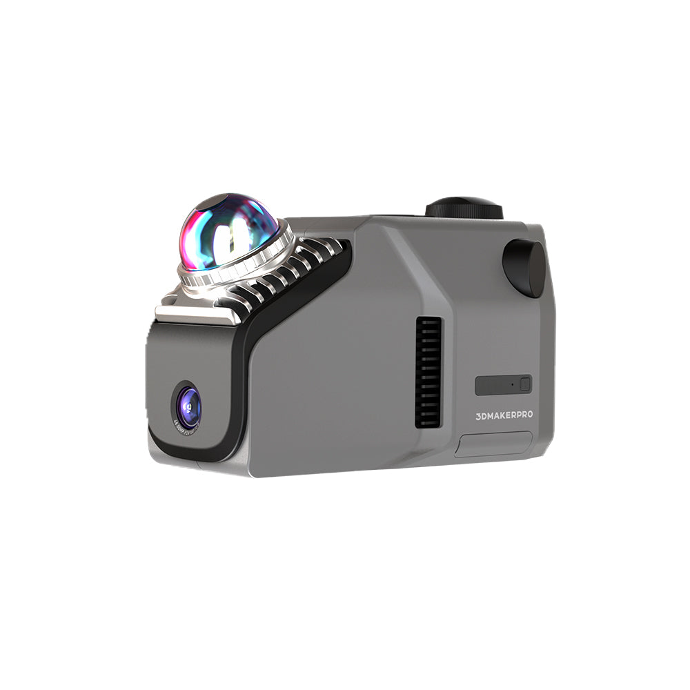
The Eagle pairs a single fisheye color camera with a 905 nm LiDAR engine that reaches 80 to 140 m and holds 2 cm accuracy at 10 m. A 360 degree by 59 degree field of view and 200,000 points per second let you cover a site in a single pass, while the included RTK Kit adds centimeter-level georeferencing for survey work.
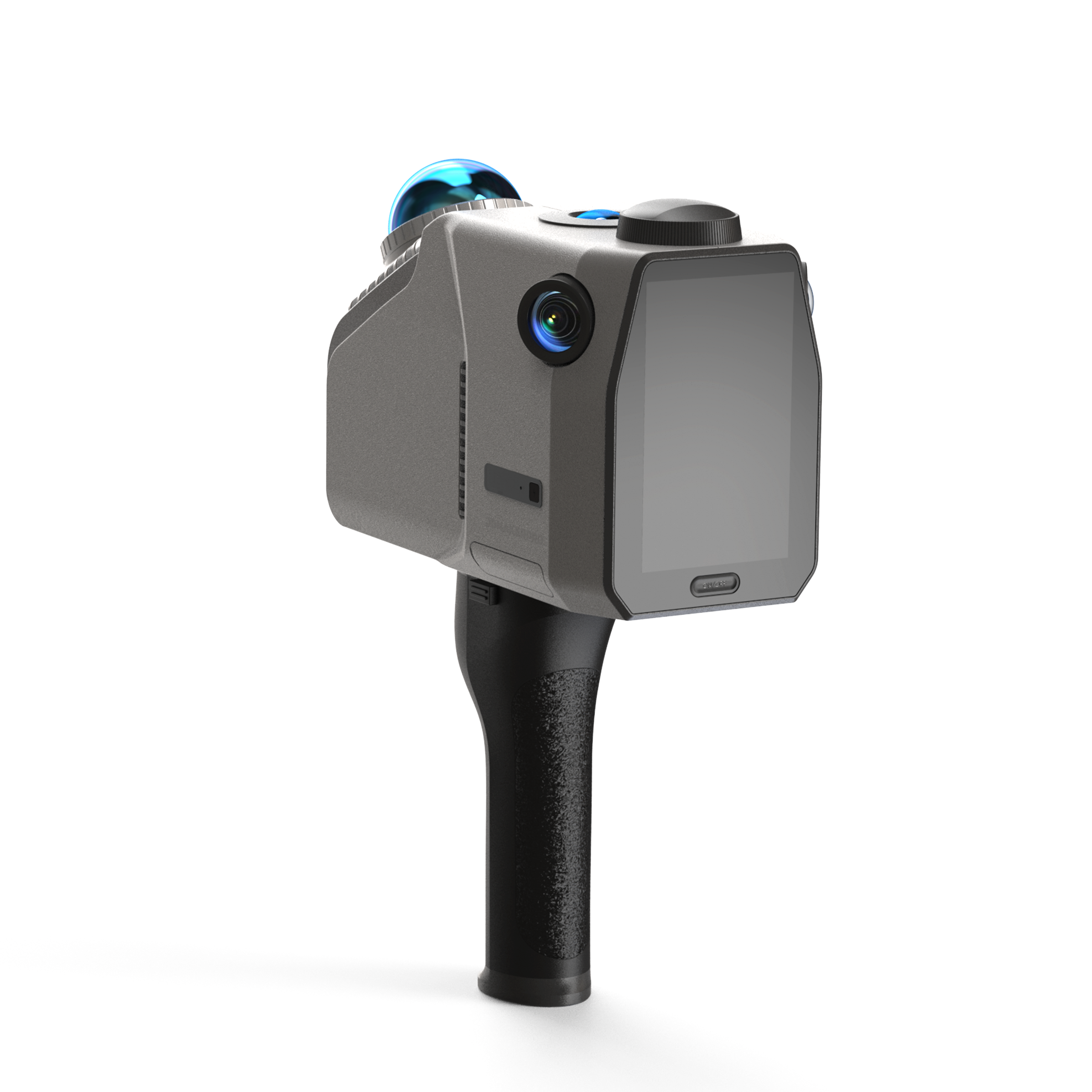
Eagle runs as a handheld unit or mounts on a tripod, backpack, bicycle, or vehicle. An on-device 3.5 inch screen shows the live point cloud and capture trajectory, so you can review coverage on site before you leave the job.
What's Included:
- 3DMakerPro Eagle LiDAR scanner (1 x camera with RTK)
- Handle
- PD power adapter
- 1.5 m dual-ended USB-C cable
- 128 GB TF card
- USB-C to USB-A adapter
- RTK Kit
- Owner's manual
Features
Single-Camera RTK Terrestrial Scanning
Eagle combines a 905 nm LiDAR engine with one fisheye color camera and an included RTK Kit, so you capture georeferenced point clouds straight from the field.

2 cm Accuracy for As-Built Work
The LiDAR engine holds 2 cm accuracy at 10 m, 3 cm at 20 m, and 5 cm at 40 m, which suits surveying, facility mapping, and as-built documentation.

80 to 140 m Range and Wide Field of View
A scan range of 80 to 140 m with a 360 degree by 59 degree field of view covers more area per pass and cuts down on repositioning across a large site.

200,000 Points Per Second
A point rate of 200,000 points per second records dense detail quickly, so complex structures and interiors are documented in less time on site.

On-Site Review with a 3.5 inch Screen
The built-in 3.5 inch screen displays the live point cloud, GPS trajectory, and camera view, so you can confirm coverage before leaving the job.

Color Point Clouds and Gaussian Splatting
The fisheye camera adds true-color texture and 8K panoramic output, and Eagle supports 3D Gaussian Splatting for realistic scene reconstructions in PLY and OBJ formats.

Flexible Mounting Options
Eagle works handheld or mounts on a tripod, backpack, bicycle, or vehicle, so a single unit handles interiors, building exteriors, and mobile street capture.

What's Included
Included with Your Purchase:
- 3DMakerPro Eagle LiDAR scanner (1 x camera with RTK)
- Handle
- PD power adapter
- 1.5 m dual-ended USB-C cable
- 128 GB TF card
- USB-C to USB-A adapter
- RTK Kit
- Owner's manual
Specifications
| Cameras | 1 x camera with RTK Kit |
| Accuracy | 2 cm at 10 m, 3 cm at 20 m, 5 cm at 40 m |
| Scan Radius | 40 to 70 m (at 10% or 80% reflectivity) |
| Scan Range | 80 to 140 m |
| Scan Angle | Horizontal 360 degrees, Vertical 59 degrees |
| Point Cloud Frequency | 200,000 points per second |
| Positioning | RTK Kit included |
| Laser Light Source | 905 nm |
| Eye Safety | Class 1 (IEC60825-1:2014) |
| Screen | 3.5 inch |
| Output Formats | PLY point cloud, Gaussian Splatting PLY, OBJ model, OBJ panoramic tour |
| Built-in Battery | 12,000 mAh (about 1 hour, external power supported) |
| Weight | 1.5 kg |
FAQ
Q: How accurate is the Eagle?
A: It holds 2 cm accuracy at 10 m, 3 cm at 20 m, and 5 cm at 40 m using its 905 nm LiDAR engine, and the included RTK Kit adds georeferenced positioning for survey work.
Q: What range does it cover?
A: The Eagle scans from 80 to 140 m, with a usable radius of 40 to 70 m depending on whether the surface reads at 10% or 80% reflectivity.
Q: Does the Eagle include RTK?
A: Yes. The Eagle ships with the RTK Kit included, so you get centimeter-level georeferencing for surveying and mapping without buying a separate module.
Q: How is the Eagle different from the Eagle Max?
A: The Eagle uses one color camera, while the Eagle Max uses four cameras for denser color and wider RGB coverage. Both share the same LiDAR engine, 2 cm accuracy, 80 to 140 m range, and 200,000 points per second.
Q: What file formats does it output?
A: Eagle outputs colorized PLY point clouds, Gaussian Splatting PLY, OBJ models, and OBJ panoramic tour data, which drop into CAD, BIM, and 3D modeling tools.
Q: Can I mount it on a vehicle or backpack?
A: Yes. Eagle works handheld or mounts on a tripod, backpack, bicycle, or vehicle rooftop for mobile and hands-free capture.