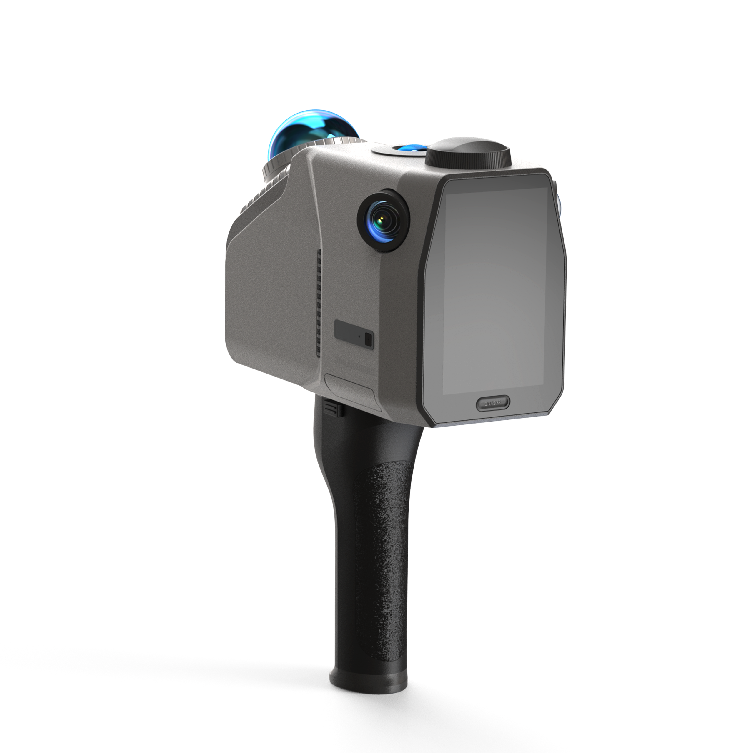
3DMakerPro Eagle Max Terrestrial LiDAR 3D Scanner
The 3DMakerPro Eagle Max is a terrestrial LiDAR 3D scanner for surveying, large-scale mapping, architecture, and full-color documentation. It builds colorized 3D point clouds of big indoor and outdoor scenes in minutes and exports them to CAD, BIM, and modeling pipelines.
Where the standard Eagle uses one camera, the Eagle Max adds four fisheye color cameras for denser RGB texture and wider color coverage in a single pass. It shares the same 905 nm LiDAR engine, 2 cm accuracy at 10 m, 80 to 140 m range, 200,000 points per second, and an included RTK Kit for centimeter-level georeferencing.
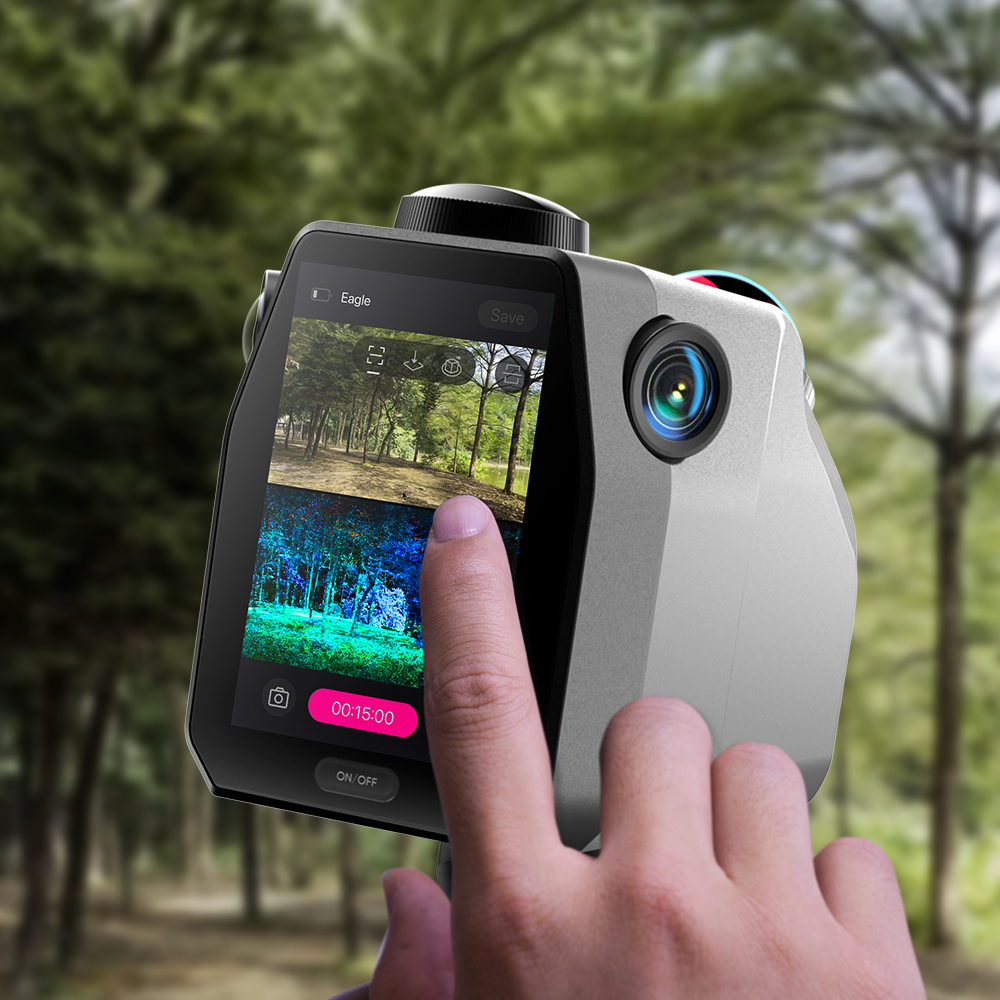
Eagle Max suits jobs where true-color output matters, such as heritage records, film and virtual sets, and detailed site documentation. It runs handheld or mounts on a tripod, backpack, bicycle, or vehicle, and an on-device 3.5 inch screen shows the live point cloud as you scan.
What's Included:
- 3DMakerPro Eagle Max LiDAR scanner (4 x camera with RTK)
- Handle
- PD power adapter
- 1.5 m dual-ended USB-C cable
- 128 GB TF card
- USB-C to USB-A adapter
- RTK Kit
- Owner's manual
Features
Four Cameras for Denser Color
The Eagle Max carries four fisheye color cameras, so it records richer RGB texture and wider color coverage than the single-camera Eagle in the same pass.

8K Panoramic Color Output
The four-camera setup feeds 8K panoramic color and HDR imaging into the point cloud, which produces vivid, detailed scenes for visualization and modeling.

RTK Georeferencing Included
Eagle Max ships with the RTK Kit included, adding centimeter-level absolute positioning for surveying and large-scale mapping straight out of the case.

2 cm Accuracy to 140 m
The 905 nm LiDAR engine holds 2 cm accuracy at 10 m and reaches 80 to 140 m, covering wide exteriors and tall structures with consistent spatial data.

200,000 Points Per Second
A point rate of 200,000 points per second and a 360 degree by 59 degree field of view capture dense detail fast, so large sites need fewer setups.

Gaussian Splatting and Flexible Output
Eagle Max supports 3D Gaussian Splatting plus PLY, OBJ, and panoramic tour exports, so the same scan feeds CAD, BIM, game, and film workflows.

Mount It Almost Anywhere
Run Eagle Max handheld or mount it on a tripod, backpack, bicycle, or vehicle rooftop, so one scanner handles interiors, exteriors, and mobile street capture.

What's Included
Included with Your Purchase:
- 3DMakerPro Eagle Max LiDAR scanner (4 x camera with RTK)
- Handle
- PD power adapter
- 1.5 m dual-ended USB-C cable
- 128 GB TF card
- USB-C to USB-A adapter
- RTK Kit
- Owner's manual
Specifications
| Cameras | 4 x camera with RTK Kit |
| Accuracy | 2 cm at 10 m, 3 cm at 20 m, 5 cm at 40 m |
| Scan Radius | 40 to 70 m (at 10% or 80% reflectivity) |
| Scan Range | 80 to 140 m |
| Scan Angle | Horizontal 360 degrees, Vertical 59 degrees |
| Point Cloud Frequency | 200,000 points per second |
| Positioning | RTK Kit included |
| Color Texture | 8K panoramic color output |
| Laser Light Source | 905 nm |
| Eye Safety | Class 1 (IEC60825-1:2014) |
| Screen | 3.5 inch |
| Output Formats | PLY point cloud, Gaussian Splatting PLY, OBJ model, OBJ panoramic tour |
| Built-in Battery | 12,000 mAh (about 1 hour, external power supported) |
| Weight | 1.5 kg |
FAQ
Q: What does the Max add over the standard Eagle?
A: The Eagle Max uses four color cameras instead of one, so it captures denser RGB texture and 8K panoramic color across a wider field. The LiDAR engine, 2 cm accuracy, 80 to 140 m range, and 200,000 points per second are the same on both.
Q: How accurate is the Eagle Max?
A: It holds 2 cm accuracy at 10 m, 3 cm at 20 m, and 5 cm at 40 m using its 905 nm LiDAR engine, and the included RTK Kit adds centimeter-level georeferencing.
Q: Does it include RTK?
A: Yes. The Eagle Max ships with the RTK Kit included, so georeferenced surveying and mapping work out of the case with no separate module to buy.
Q: What range and coverage does it offer?
A: Eagle Max scans from 80 to 140 m with a 360 degree by 59 degree field of view, and a usable radius of 40 to 70 m depending on whether the surface reads at 10% or 80% reflectivity.
Q: What can I do with the color data?
A: The four cameras produce 8K panoramic color point clouds and support 3D Gaussian Splatting, which suits heritage records, film and virtual sets, and detailed site documentation.
Q: What file formats does it export?
A: Eagle Max outputs colorized PLY point clouds, Gaussian Splatting PLY, OBJ models, and OBJ panoramic tour data for CAD, BIM, and 3D modeling tools.